


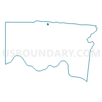
Voting District FOREST PARK F, Hamilton County, Ohio
About
Outline

Summary
| Unique Area Identifier | 647423 |
| Name | Voting District FOREST PARK F |
| County | Hamilton County |
| State | Ohio |
| Area (square miles) | 0.18 |
| Land Area (square miles) | 0.18 |
| Water Area (square miles) | 0.00 |
| % of Land Area | 100.00 |
| % of Water Area | 0.00 |
| Latitude of the Internal Point | 39.29537400 |
| Longtitude of the Internal Point | -84.55960450 |
Maps

Graphs
Select a template below for downloading or customizing gragh for Voting District FOREST PARK F, Hamilton County, Ohio


Neighbors
Neighoring Voting District (by Name) Neighboring Voting District on the Map
- Voting District COLERAIN EE, Hamilton County, OH
- Voting District COLERAIN OO, Hamilton County, OH
- Voting District FOREST PARK K, Hamilton County, OH
- Voting District SPRINGFIELD FF, Hamilton County, OH
Top 10 Neighboring County Subdivision (by Population) Neighboring County Subdivision on the Map
- Colerain township, Hamilton County, OH (58,499)
- Springfield township, Hamilton County, OH (36,319)
- Forest Park city, Hamilton County, OH (18,720)